Introduction
'Mapping the Lakes' is a collaborative and explorative research project. Funded by the British Academy, the pilot project tests whether Geographic Information Systems (GIS) technology can be used to further the understanding of the literature of place and space.
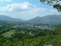 'Mapping the Lakes' maps out two textual accounts of journeys through the landscape of the Lake District: Thomas Gray's tour of the region in the autumn of 1769; and Samuel Taylor Coleridge's 'circumcursion' of the area in August 1802. This website offers GIS representations of these two accounts of place and suggests ways in which the mapping process opens up spatial thinking about these geo-specific texts. The project also offers general reflections on the intersections of digital cartography and electronic textuality, paving the way for future research on the literature of landscape and environment.
'Mapping the Lakes: Towards a Literary GIS' emerges out of the work of the Wordsworth Centre for the Study of Poetry, based within the Department of English & Creative Writing at Lancaster University, and the University's increasing interest in digital humanities. The project is led by Dr Ian Gregory (Senior Lecturer, Digital Humanities) and Dr Sally Bushell (Senior Lecturer in English Literature and Co-Director of the Wordsworth Centre). Dr David Cooper is the post-doctoral researcher who has co-ordinated and handled the theoretical and practical application of the project. Zoe Bolton, a doctoral student in the Department of English & Creative Writing, has provided content on Thomas Gray and co-designed the project website.